
The hum of the highway is the sound of an economy in motion. In India, where National Highways (NH) form the circulatory system of a rapidly growing nation, managing this complex flow of vehicles is paramount. But how does the government actually know how many vehicles use a specific stretch of road?
Welcome to the world of traffic counts on National Highways. While seemingly bureaucratic, understanding traffic volume—the “pulse” of our highways—is fundamental to building safer roads, reducing congestion, and making data-driven infrastructure decisions. From rural corridors to busy multi-lane expressways like those near Vadodara, traffic data collection is undergoing a high-tech revolution.
This 2025 guide explores why traffic counts are critical, the different methods used, and how data is shaping the future of Indian transportation.
Why Do We Need Traffic Counts?
Think of a traffic count as a diagnostic tool for our road network. Collecting precise data serves several vital purposes:
1. Infrastructure Planning & Development: The most critical use is planning new roads, expanding existing ones, and designing safer junctions. When engineering new highways, such as those planned under the Bharatmala Pariyojana, knowing the existing and projected traffic load is non-negotiable.
2. Optimizing Road Safety: Analyzing traffic density helps identify bottlenecks and high-risk zones, often called black spots, where accidents frequently occur. This allows road safety engineers to implement targeted measures like better signage, improved street lighting, or the creation of service lanes. For areas experiencing rapid growth, like Gujarat, accurate traffic counts around key industrial hubs (such as GIDC estates) are essential for managing safety and flow.
3. Economic Modeling and Logistics: Traffic volume is a direct indicator of economic activity. The movement of freight—tracked through automatic vehicle classification—tells economists about industrial output and consumer demand. Reducing travel time on busy routes can lower logistics costs from 14% to a target of 9% of GDP, a central goal of India’s recent policies.
4. Public Transit and Urban Sprawl Management: Understanding peak hour traffic helps city planners around hubs like Vadodara design efficient public transport corridors and manage the environmental impact of urban expansion.
How is Traffic Counted on Indian Highways in 2025?
The methods used on India’s massive, 1,46,560 km+ National Highway network have evolved from simple tallies to sophisticated digital systems.
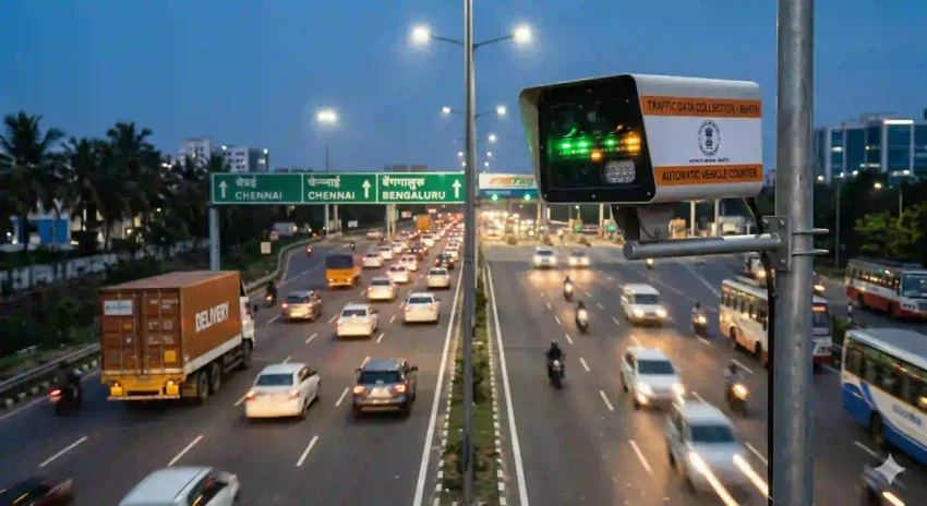
1. Automatic Vehicle Counters and Classifiers (AVCC): This is now the dominant, highly accurate method. Using magnetic loops embedded in the tarmac, piezoelectric sensors, or video processing, AVCC systems automatically count vehicles and classify them (e.g., car, truck, multi-axle vehicle). This provides 24/7 data, minimizing human error.
2. FASTag Data Integration: With FASTag achieving nearly 98% penetration at toll plazas, this digital payment system is also a powerful data collection tool. Each transaction records the passage of a unique vehicle, providing real-time flow data and enabling sophisticated analysis of travel patterns.
3. Satellite Tolling and GNSS: The recent pilot of Global Navigation Satellite System (GNSS) tolling takes this a step further. Money is deducted based on the exact distance traveled. This system not only eliminates physical toll booths but also provides hyper-local, precise traffic density data across entire highway segments.
4. Temporary Manual Counts (AADT): While automated methods are preferred, temporary manual counts—usually for 24-48 hours—are still used for specific studies, validation, or where automated systems are not yet installed. These are extrapolated to calculate the Annual Average Daily Traffic (AADT).
5. Crowdsourced Data and AI: Increasingly, data from mobile phones and navigation apps, processed using advanced Artificial Intelligence, provides real-time traffic speeds and congestion indices, complementing official highway count data.
Case Study: The Traffic Landscape around Vadodara
As a major industrial and logistics hub in Gujarat, Vadodara offers a perfect microcosm of highway challenges. The National Highways converging on the city are some of the busiest in Western India. High traffic counts here directly translate to:
-
Increased wear-and-tear on critical segments.
-
Congestion during peak industrial commute hours.
-
A higher risk of accidents involving mixed traffic (logistics trucks and smaller passenger vehicles).
The effective application of AVCC systems, optimization of FASTag lanes, and potential rollout of GNSS in the Vadodara region will be crucial in ensuring that these critical arteries support, rather than hinder, economic momentum.
Conclusion: Data-Driven Roads for a ‘Viksit Bharat’
The days of making infrastructure decisions based on estimates are over. In 2025, robust traffic count data is the blueprint for a smarter, safer, and more efficient India. By leveraging technology to monitor the pulse of our highways, we are not just counting cars; we are optimizing the movement of people and goods that drives India towards its goal of becoming a $5 trillion economy.
Stay tuned to General Info for more in-depth analyses of India’s changing infrastructure and the technology powering our progress!